War on the Moor: Military Training on Exmoor
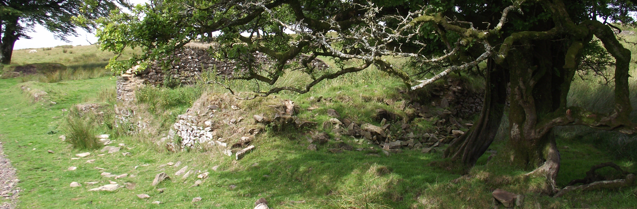
(Ruined buildings at Larkbarrow Farm; © ENPA 2013)
The tranquillity of Exmoor today is in stark contrast to the early 1940s. Bristling with military equipment and activity, a large area of the moor was used by the army during the Second World War for training purposes. Many wartime activities have been identified on 1940s aerial photographs and some traces survive on the ground today.
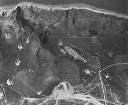 Along the coast, tanks arrived at Minehead Station and were driven along the seafront to the Armoured Fighting Vehicle ranges on North Hill. Local residents, Peter Batchelor and Dudley Parsons, recall the tank’s caterpillar tracks tearing up the roads and damaging iron railings as they passed (SRO A/BJS 3/13, SRO A/BJS 3/29). The remains of military roads still cross North Hill. The tanks simulated battle conditions by driving around three triangular firing ranges at Bossington Hill, Selworthy Beacon and North Hill, visible on aerial photographs, firing at targets which moved along target railways on their seaward side (Bossington Hill, Selworthy Beacon and East Myne). Any missed shots fell harmlessly out to sea or on dead ground, which had been specially prepared. Peter Batchelor described living near the range as like living in a war zone, but the noise of the tanks firing became part of everyday life (SRO A/BJS 3/13). The triangular tracks and targets still survive on North Hill, surrounded by the remains of small observation posts and machine gun emplacements.
A swathe of largely unsettled northwest Exmoor was requisitioned for artillery practice as part of the Exmoor Firing Range. Heavy guns fired at targets inside the former Royal Forest, the best known being the 19th century model farms at Tom’s Hill and Larkbarrow, which were almost totally destroyed. Arthur Webber describes how observers could see the flash of the guns, followed two or three seconds later by the noise of the impacting shell (SRO A/BJS 3/31). Shell holes pepper over twenty square kilometres of the moor. Dense concentrations reveal further possible targets, such as an enigmatic V-shaped arrangement of ditches on Porlock Common. This might have contained a moving target, perhaps similar to those used on North Hill. Three flat concrete squares no more than five metres across have been identified from aerial photographs on Brendon Common, Stowey Allotment and at Outer Alscott, each lying within or close to concentrations of craters. Their function remains unknown, but the twisted remains of metal posts protruding from the crumbling concrete suggests they could have held markers or signs, or perhaps themselves defined a firing range target.
 It is likely that some of the craters were created by experimental rockets, which were developed on the Exmoor Firing Range. These five inch rockets were trialled by the Chemical Warfare troops of the Royal Engineers under the command of Colonel R.H. Maclaren. They were designed to carry gas filled warheads, although they were never used as such. The rockets were tested on Brendon Common, often firing down Badgeworthy Water. Local farmers frequently complained of rockets over-flying the firing range boundary. It was whilst demonstrating this new equipment to War Office officials on the 20th May 1941 that a failure caused a barrage of rockets to go astray, killing Colonel Maclaren. A monument to him now stands on Brendon Common, not far from where he fell.
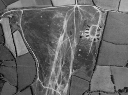
The Exmoor Firing Range was also used for infantry training. The ephemeral remains of numerous small trenches or pits known as slit trenches and weapons pits, and a variety of other less readily identifiable earthworks have been recorded from 1940s aerial photographs. Vehicle tracks may also be evidence of motorised training, or perhaps simply mark routes taken to the training areas from military camps. All troops training on the moor required accommodation and several temporary tented camps have been identified. A small camp on Tippacot Ridge near Brendon probably housed many of those who trained on the firing range throughout the war. At 15 men to a tent, the camp probably accommodated about 750 troops at any one time, excluding the officers who were probably accommodated in more permanent, and undoubtedly more comfortable, Nissen huts. Such long term camps required permanent facilities such as a wash house, cook house and latrine. Ruined structures still visible may be the remains of these facilities.
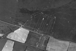 A camp at Treborough on the Brendon Hills was much larger, but was made for a very specific and short-lived purpose. Built to house American troops in advance of the D-Day landings, 5000 soldiers could easily have been housed in this large camp. However, due to its short-lived existence the remains of this camp are much more ephemeral, visible on aerial photographs only as the ghostly footprints of lines of bell tents and remains of the enclosing bank.
Cain Hegarty
Further Reading
SEM7230 Burton, R.A. 1989. 'The Heritage of Exmoor'. Roger A. Burton, p225.
SEM6848 Crowther, S. and Dickson, A. 2008. 'Severn Estuary Rapid Coastal Zone Assessment Survey'. Unpublished Survey Report. Applications for reproduction should be made to Gloucestershire County Council (archaeology.smr@gloucestershire.gov.uk) or English Heritage (nmrinfo@english-heritage.org.uk ).
SEM8624 Lloyd, T.I. 1981. 'Let’s Remember Bobby Maclaren'. Royal Engineers Journal, p60-64.
SSO1298 Lowry, B (Ed.). 1996. '20th Century Defences in Britain: An Introductory Guide'. Council for British Archaeology.
SEM7440 Riley, H. and Wilson North, R. 2001. 'The Field Archaelogy of Exmoor'. English Heritage.
Image credits
Image 1: North Hill Armoured Fighting Vehicle ranges, RAF_106G_UK_1655 fr. 4011 (11 July 1946), Historic England (RAF Photography)
Image 2: Training camp at Tippacott Ridge, RAF_106G_UK_1655 fr. 3079 (11 July 1946), Historic England (RAF Photography)
Image 3: Camp at Treborough Common, RAF_106G_UK_1655 fr. 3323 (11 July 1946), Historic England (RAF Photography)