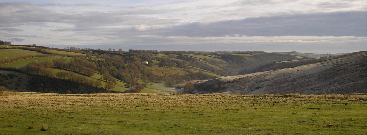
Farms and Fields
(© ENPA 2012)
The basic settlement unit on Exmoor is the isolated farm. Bigger settlements such as hamlets and villages (like Dulverton and Withypool) also exist. Taken together these units form a complex pattern of settlement, which is essentially dispersed. Such a complex pattern also has a dynamic structure. It is not surprising to find that settlements expand, contract, amalgamate or disappear. A good example can be seen on the edge of Molland Common at Lyshwell, where the remains of several deserted farmsteads (North Lyshwell and northeast of Lyshwell Farm) may have previously formed a hamlet with the surviving Lyshwell, Cloggs and Shircombe Farms. Individual farms within a hamlet may have been abandoned, but the settlement continues, albeit in an altered form.
Some settlements failed in the medieval period, such as Badgworthy, Mansley Combe, Ley Hill, Grexy Combe and Sweetworthy, and there are examples of farmsteads being deserted right into the 20th century. However, desertions are relatively rare and it is much more common for settlements to alter in size and complexity over time.
The archaeological evidence for settlement contraction is often less clear than for desertions, where earthworks or ruined structures may clearly identify the former settlement. In settlement contraction or amalgamation, deserted buildings may be adapted or absorbed into the surviving farms, but it is just as likely that they might be removed altogether. As Harold Fox said, by this process “a hamlet grouping of farmsteads around a small green would eventually become a deceptively simple collection of outbuildings around a spacious farmyard.”
This process of farm ‘engrossment’ is sometimes reflected in the landscape. The earthwork remains of relict communal medieval strip fields have been fossilised within the modern field pattern at West Lyn, near Lynton and Lynmouth. Although similar to more extensive strip field earthworks still visible around the hamlets of Parracombe and Challacombe, the West Lyn remains are largely now within the holding of a single farm and reflect the process of settlement contraction.
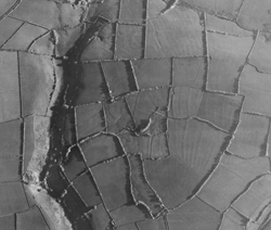 The survival of the medieval land use pattern at West Lyn is unusual. In many places, where earthwork evidence for medieval strip fields survive they have been superseded by later reorganisation that largely disregards the earlier field pattern. A good example can be seen around the deserted farmstead of North Thorne, Bratton Fleming (image to left; Copyright Historic England, as below). As at West Lyn and Challacombe, elements of the curvilinear medieval field pattern are preserved in the modern field boundaries around the deserted farm. Beyond these, however, the character of enclosure changes dramatically. Straight and regular enclosure fences, associated with the surviving modern North Thorne farm are clearly imposed onto the earlier strip fields, suggesting that a large-scale reorganisation of the former hamlet’s field system occurred in the post medieval period, perhaps after a prolonged period of abandonment. This new pattern was itself disrupted in the 1950s, with the construction of Wistlandpound reservoir, and by the 1970s the medieval strip field earthworks had been all but levelled.
Cain Hegarty
Further Reading
SEM6811 Fox, H.S.A. 1983. 'Contraction: Desertion and dwindling of dispersed settlement in a Devon Parish.' Annual Report of the Medieval Village Research Group, 31, 40–42.
SEM8306 Hegarty, C. and Wilson-North, R. 2014. 'The Archaeology of Hill Farming on Exmoor'. English Heritage.
SEM7541 Siraut, M. 2009 'Exmoor: The Making of an English Upland'.
Image credits
Image 1: North Thorne field system; RAF_CPE_UK_2082 fr.3096 (19 May 1947), Historic England (RAF Photography)